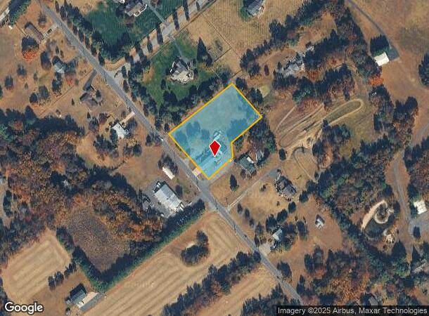
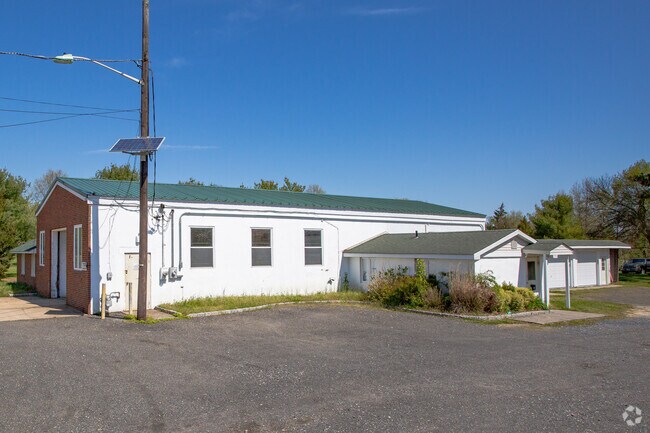
Property Record
220 Eayrestown Rd, Southampton, NJ 08088

NEARBY LISTINGS FOR SALE OR LEASE
Property Detail
220 Eayrestown Rd
33-01802-0000-00008-05
Burlington
Commercialnec
New Jersey
X
8.5
34005C0269F
2 AC
2024
South Burlington County
2025
Philadelphia
703202
Philadelphia-Camden-Wilmington, PA-NJ-DE-MD
DEMOGRAPHICS near 220 Eayrestown Rd
1 Mile
3 Mile
5 Mile
2024 Total Population
304
9,876
38,074
2029 Population
308
10,021
38,650
Pop Growth 2024-2029
+ 1.32%
+ 1.47%
+ 1.51%
Average Age
42
50
46
2024 Total Households
103
4,308
14,943
HH Growth 2024-2029
+ 0.97%
+ 1.60%
+ 1.61%
Median Household Inc
$99,999
$81,177
$115,001
Avg Household Size
2.90
2.30
2.50
2024 Avg HH Vehicles
3.00
2.00
2.00
Median Home Value
$497,367
$281,344
$357,689
Median Year Built
1979
1977
1977
Nearby Places
Map Layers
Map Styles
 Street
 Aerial
- Restaurants
- Banks
- Shops
- Fitness
- Groceries
PUBLIC TRANSPORTATION
AIRPORT
Trenton Mercer
DRIVE
WALK
Distance
Trenton Mercer
48 min
31.9 mi
Philadelphia International
DRIVE
WALK
Distance
Philadelphia International
49 min
32.9 mi
Atlantic City International
DRIVE
WALK
Distance
Atlantic City International
71 min
40.4 mi
Nearby Properties
Address
Land Use
TOTAL SIZE
Lot Size
Zoning
Address
Land Use
TOTAL SIZE
Lot Size
Zoning
49.38 AC
PPE
Address
Land Use
TOTAL SIZE
Lot Size
Zoning
5.29 AC
TC
Address
Land Use
TOTAL SIZE
Lot Size
Zoning
57.38 AC
PPE
Address
Land Use
TOTAL SIZE
Lot Size
Zoning
23.70 AC
HM
Address
Land Use
TOTAL SIZE
Lot Size
Zoning
20,460 SF
23.95 AC
AR
Address
Land Use
TOTAL SIZE
Lot Size
Zoning
1.64 AC
SGRA
Address
Land Use
TOTAL SIZE
Lot Size
Zoning
1,750 SF
7.91 AC
I
Address
Land Use
TOTAL SIZE
Lot Size
Zoning
5,522 SF
5.14 AC
HM
Address
Land Use
TOTAL SIZE
Lot Size
Zoning
5.63 AC
HC
Address
Land Use
TOTAL SIZE
Lot Size
Zoning
16.50 AC
PPE
Address
Land Use
TOTAL SIZE
Lot Size
Zoning
8.38 AC
HC
Address
Land Use
TOTAL SIZE
Lot Size
Zoning
9,271 SF
1 AC
RS-2
Address
Land Use
TOTAL SIZE
Lot Size
Zoning
0.70 AC
TC
Address
Land Use
TOTAL SIZE
Lot Size
Zoning
Address
Land Use
TOTAL SIZE
Lot Size
Zoning
9.37 AC
I
Address
Land Use
TOTAL SIZE
Lot Size
Zoning
8,225 SF
6 AC
HM
Address
Land Use
TOTAL SIZE
Lot Size
Zoning
3.45 AC
I
Address
Land Use
TOTAL SIZE
Lot Size
Zoning
31 AC
TCHC
Address
Land Use
TOTAL SIZE
Lot Size
Zoning
1,400 SF
3 AC
HM
Address
Land Use
TOTAL SIZE
Lot Size
Zoning
0.38 AC
TC
Address
Land Use
TOTAL SIZE
Lot Size
Zoning
24,360 SF
15.77 AC
I
Address
Land Use
TOTAL SIZE
Lot Size
Zoning
8,372 SF
2.96 AC
HM
Address
Land Use
TOTAL SIZE
Lot Size
Zoning
15.65 AC
HC
Address
Land Use
TOTAL SIZE
Lot Size
Zoning
9,300 SF
26.36 AC
HC
Address
Land Use
TOTAL SIZE
Lot Size
Zoning
2.09 AC
HC
Address
Land Use
TOTAL SIZE
Lot Size
Zoning
3,366 SF
5 AC
AR
Address
Land Use
TOTAL SIZE
Lot Size
Zoning
16,000 SF
2.40 AC
I
Address
Land Use
TOTAL SIZE
Lot Size
Zoning
50.50 AC
MC
Address
Land Use
TOTAL SIZE
Lot Size
Zoning
4,020 SF
2.50 AC
GMN
Address
Land Use
TOTAL SIZE
Lot Size
Zoning
5.30 AC
I
The World's #1 Commercial Real Estate Marketplace
Connect with us
© 2026 CoStar Group
The information above has been obtained from sources believed reliable. While we do not doubt its accuracy we have not verified it and make no guarantee, warranty or representation about it. It is your responsibility to independently confirm its accuracy and completeness. Any projections, opinions, assumptions, or estimates used are for example only and do not represent the current or future performance of the property. The value of this transaction to you depends on tax and other factors which should be evaluated by your tax, financial, and legal advisors. You and your advisors should conduct a careful, independent investigation of the property to determine to your satisfaction the suitability of the property for your needs.